Wilderness
Survival: Travel In the Woods
If
you do become lost, stay where you are. Build a fire
and carefully assess the situation. Do not use precious
energy by wandering aimlessly.
During
the winter months use game trails which will help
you avoid walking in the deep snow. Frozen streams
and rivers are also easy to follow but watch for weak
ice.
MEASURING
DISTANCE
When
measuring distance the most effective method is the
tally and pace system:
1 pace = 75 cm (29.25 in)
1 double pace = 150 cm or 1.5 m (58.5 in)
66 double paces = 99 m (107.9 yards) = 1 tally (tie
a knot in a string for each tally)
10 tallies = 1000 m or 1 km (0.62 mi)
FINDING
DIRECTION
 Using
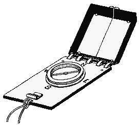
a Compass Using
a Compass
(Note: When using a compass in coastal British
Columbia, it will read 22 degrees east of true north.
More time must be allowed to read a bearing during
the winter months as it takes longer for the needle
to finish swinging.)
A
magnetic-Sylva type compass is a lost hiker's best
friend. First, decide which direction you want to
follow then aim over the centre of your compass to
the bearing you want to follow and find a landmark
on this sighting. After arriving at this landmark
repeat the process. Using this pattern you will follow
a relatively straight line.
 Using
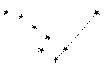
the Stars Using
the Stars
For those unfortunate enough to not have a compass,
using the pole star for direction will suffice. Simply
located the pole star and you will be facing north.
To find this star use the Big Dipper constellation.
The pole star will be located off of the top of the
"dipper", on the opposite side of the handle.
 Using
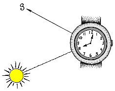
the Sun Using
the Sun
You may also use your watch and the sun to determine
direction. Point the hour hand directly at the sun
and then bisect the angle between the hour hand and
twelve o'clock. This imaginary line will run north/south.
METHODS
OF NAVIGATION
There
are three common methods of navigation:
1.
Map reading is a common method used, particularly
in developed areas. Maps and aerial photos may be
used when landmarks are clear.
2.
Using a compass in conjunction with maps and aerial
photos is wise in areas without good landmarks.
3.
Navigation by dead reckoning is common in areas
where landmarks are non-existent or inadequate.
This method combines plotting and recording of a
series of courses, measured by distance and direction
from a starting point.
*
It is important to stay alert and observe all unusual
landmarks.
Difficulties
in navigation may occur for several reasons. Some
of these include
WHEN
YOU'RE LOST IN THE WOODS
The
most important thing to remember if you find yourself
in this situation is not to panic. First, treat any
injuries within your party. Next, establish that your
basic needs are met. These include heat, shelter,
water and food. Then consult your map and compass
and try to recognize or remember landmarks you may
have passed.
To
determine how many hours of daylight are left, face
the sun and extend your arm towards it. Bend your
wrist inwards and place your fingers just below the
sun. Disregarding your thumb, count how many fingers
separate the sun from the horizon. Each finger will
represent fifteen minutes.
If
it is nearing dark, build a shelter and fire that
is on high ground and out of the wind. Have a snack
and a hot drink and get some rest. Don't waste precious
energy by trying to find your way in the dark.
During
daylight hours it is important to find a way to signal
to others. A fire is best. Be sure to find a means
with which to carry water. If you must move be sure
to leave markers that searchers can follow.
SIGNALS
A
fire is the safest method to use when signaling for
help. The smoke is easily spotted during the day and
the flames by night. Three signal fires laid 30 m
(98 feet) apart and lit when a aircraft passes is
a good way to indicate your distress. The Morse Code
emergency signal is S...O...S... and may be sent with
a flashlight and consists of three dots followed by
three dashes followed by three dots. The dashes should
be twice as long as the dots. Messages or signal letters
may be drawn in the snow. A signal mirror is also
a very effective method used. Flash the mirror along
the horizon regardless of whether a plane is in view.
Before
venturing into the wilderness check weather forecasts
and hazards.
Basic
Survival | Travel
| Food & Water
First Aid & Health
Outdoor
& Survival Training
|

 Using
a Compass
 Using
the Stars
 Using
the Sun